Why every flat map stretches something
Grade 6 Social Studies Worksheet - Challenge Me

Circle the best answer.
At 60° N, a Mercator map draws land 2 times too wide and 2 times too tall. How many times too big does Pia see its area?
- 4 times too big
- 2 times too big
- 8 times too big
- 1 time: the area is true
At about 70° N, Ren's Mercator map draws land about 3 times too wide and 3 times too tall. About how many times too big does its area look?
- About 6 times too big
- About 3 times too big
- About 27 times too big
- About 9 times too big
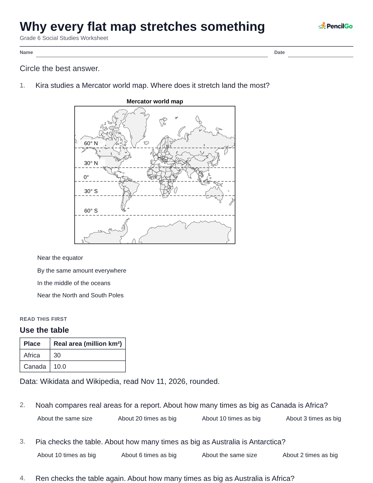
Data: Wikidata and Wikipedia, read Nov 11, 2026, rounded. Beside it, a Mercator map where Alaska looks larger than Mexico. Zee's friend says Alaska is bigger than Mexico, because Alaska looks much bigger on a Mercator map. Which response is right?
- Agree: a flat map shows sizes correctly
- Disagree: the map stretches Mexico, near the equator
- Agree: lands farther north are bigger
- Disagree: Mexico is bigger; the map stretches far-north Alaska
Ari's friend says a Mercator map is useless. Which response is right?
- Disagree: it keeps compass directions straight for sailors
- Disagree: it shows sizes correctly
- Agree: it shrinks the lands near the poles
- Agree: it is the one flat map that bends anything
Bo's friend says an equal-area map is the best map for every job. Which response is right?
- Disagree: it makes the poles look too big
- Agree: it keeps sizes and shapes true
- Agree: Mercator is the kind of map that bends land
- Disagree: it keeps sizes true but bends shapes
World map with straight, parallel longitude lines; latitude lines at 0°, 30°, 60° spaced wider and wider toward the poles. On Esme's Map P, latitude lines spread farther apart toward the poles, and longitude lines never meet. Which map is it, and what does it get wrong?
- Equal-area: land keeps its true shape
- Mercator: land near the equator looks too big
- Equal-area: land near the poles looks too big
- Mercator: land near the poles looks too big
On Jun's Map Q, latitude lines crowd closer together toward the poles, and land near the poles looks short and wide. Which map is it, and what does it keep?
- Equal-area: shapes true, sizes squashed
- Mercator: nothing is stretched or squashed
- Equal-area: sizes true, shapes squashed
- Mercator: sizes true, shapes squashed
Kira's Map R keeps every small shape right, and steady compass courses are straight lines on it. Which map is it, and what does it get wrong?
- Equal-area: sizes are wrong near the poles
- Mercator: sizes are wrong near the poles
- Globe: it keeps sizes and shapes true
- Mercator: sizes are wrong near the equator
Luz's note says: "Mercator maps stretch land most near the equator." Which fix makes the note right?
- Change "most" to "evenly"
- Change "land" to "oceans"
- Change "equator" to "poles"
- Change "stretch" to "keep the true size of"
Milo's note says: "2 times too wide and 2 times too tall means 2 times too big in area." Which fix makes it right?
- Leave it at 2 times; it is already right
- Change it to 8 times, because 2 × 2 × 2 = 8
- Change it to 4 times, because 2 × 2 = 4
- Change it to 4 times, because 2 + 2 = 4